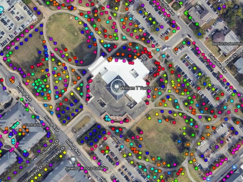
Urban Forest Initiative Tree Inventorying Resources

Tree inventorying has been a part of the Urban Forest Initiative's ongoing activities for several years. A tree inventory involves collecting information (species, size, etc.) on individual trees. We have found that tree inventorying is a multi-faceted approach to better engagement with the urban and community forest. For example, we've used tree inventorying as an educational activity with neighbors and students so that they can learn more about the trees around them. We've also led tree inventorying efforts in concert with land managers, creating a valauble resource for decision making and planning. Additionally, tree inventory data enables us to engage in urban and community forestry research by exploring landscape phenomena using information on large collections of trees. Below are several resources stemming from our tree inventorying efforts.


Tree canopy assessment and tree inventorying: a quick introduction to tree inventory methods.

Nic Williamson (UFI Coordinator) gives a short virtual talk on two categores of assessing trees in the urban and community forest. A tree canopy assessment provides information on the quantity of tree canopy within a given locale, whereas a tree inventory includes a consistent set of parameters on individual trees within the community forest. These approaches can provide information to help shape urban and community forestry efforts and management decisions.


Coming soon: 

How do you measure a tree? What is the importance of this data? Check back soon (Summer/Fall 2022) for a video that details why we measure trees.


Community tree inventorying and outreach in Lexington, KY 

Urban Forest Initiative Neighborhood Tree Inventorying


Lexington Street Tree Report

To prepare our urban forest for our changing climate, the UFI core team sought to learn more about the species composition, health, condition, and size distribution of Lexington's street trees through the support of a 2020 UK Sustainability Challenge Grant. We sampled and mapped a subset of street trees in Lexington neighborhoods, using data collected from 2018 to 2021. Our aim was to provide the Lexington-Fayette Urban County Government (LFUCG) Urban Forestry group, LFUCG councilmembers, the Lexington Tree Board, and local residents with a tool for guiding future planting decisions and ongoing management of street trees, particularly in the face of a changing climate and other threats to Lexington’s tree canopy.


Lexington Public Parks Tree Reports

From May to July, 2022, the Urban Forest Initiative Core Team, with the help of community volunteers, inventoried trees in twelve of Lexington's public parks to help prepare our local tree canopies for climate change. These reports showcase key information for each park regarding tree species composition, health, size diversity, and vulnerability to climate change, with the goal of providing the Lexington-Fayette Urban County Government (LFUCG) Urban Forestry group, LFUCG Parks and Recreation, LFUCG councilmembers, and local residents with a tool for guiding future planting decisions and ongoing management of Lexington's parks, particularly in the face of a changing climate and other threats to Lexington’s tree canopy.

View all of the reports here


Other Lexington Tree Reports

Tree inventorying can promote engagement between residents and the trees in their community. The Urban Forest Initiative has collected tree data with the help of Lexington community members, compiling tree reports for neighborhood associations and groups to educate and aid in planting projects. See examples from the Hill N' Dale neighborhood and the African American Cemetery No. 2 below.

Urban Forest Initiative Hill N Dale Neighborhood Report Read the Hill N' Dale Neighborhood Street Tree Report

Urban Forest Initiative African American Cemetery No. 2 tree brochure Read the African American Cemetery No. 2 Tree Brochure


University of Kentucky Campus Tree Inventorying

Urban Forest Initiative Campus Tree Inventorying

The Urban Forest Initiative collaborates with the University of Kentucky Facilities Management to build and update a tree database of campus trees. This database assists with daily management and long-term planning of the UK campus forest and is a resource for the UK and Lexington community to learn more about campus trees. 

Urban Forest Initiative TreePlotter map Explore the UK TreePlotter map here (link will take you off-site)


Park Hills Street Tree Report

Urban Forest Initiative Park Hills KY Tree Inventory  Urban Forest Initiative Park Hills KY Tree Inventory

Street tree inventory report of the city of Park Hills, KY by the University of Kentucky Urban Forest Initiative (UFI). Goal was to provide a useful tool in managing Park Hills’ street tree resources in partnership with the City of Park Hills and the county-wide GIS support unit, Planning and Development Services of Kenton County.

Urban Forest Initiative Park Hills KY Tree Inventory Read the Park Hills Street Tree Report


Elmwood Stock Farm Tree Inventory

Urban Forest Initiative Elmwood Stock Farm Tree Inventory

The Urban Forest Initiative and Elmwood Stock Farm partnered to inventory farm trees at Elmwood Stock Farm in Georgetown, KY, culminating in a report quantifying the status of the tree canopy, ecosystem benefits, recommendations and considerations for future management and projects highlighting the importance of trees at urban-rural interface. 

Report coming soon, check back Summer 2022!


Hazard Tree Inventorying and Mapping 


In June of 2021, the Urban Forest Initiative (UFI) team and volunteers from Hazard, Kentucky mapped and inventoried trees at Hazard Community and Techincal College (HCTC) along with other sites around Hazard. This project was a part of UFI'S Landscape Scale Restoration and the goal was to provide the community of Hazard with information about their tree canopy, the ecosystem benefits it provides, as well as considerations for future management of the canopy. This tree report hightlights this information for two sites where inventorying and mapping efforts were made: HCTC campus and one of Hazard's downtown roads, North Main Street.